Four winners have been announced in the UK government Transport for London accessible app competition. Here is a description of the apps from the developers (press release):
Best visually impaired app: London’s Nearest Bus. Big Ted Ltd
Standing at a London Bus Stop, wondering when the bus is going to show up? Nearest Bus will find the stop you are at, and tell you when the next bus is going to arrive. If you are near a number of bus stops, just swipe to find the one you are actually at – you can even use the local bus stop codes (eg HK, WA) to make sure you are looking at the right information. Nearest Bus will load up to 16 bus stops, 250m in all directions around you.
Nearest Bus is designed to be super quick to use – get in, find out where you bus is, and get out. And if you use VoiceOver on your iPhone, Nearest Bus is designed to get you the information you need as quickly as possible. Nearest Bus uses the same bus arrival data that the official red-on-black TfL Countdown displays use, which means that you can be assured of the same accuracy even if you are in the back end of Barnes or the middle of Trafalgar Square. Except it’s in your pocket, and at every bus stop.
Best app for accessibility / step free information: Station Master. Matthew Frost & Geoff Martiall
Station Master makes travel in London easier for everyone! If you’re one of the millions of people who use London’s Underground every day, you’ll know it’s not only the trains that can be really crowded, but you have to pick your way along platforms and corridors too. As well as carriage and door positions for the exits and interchanges, the facilities, history and fun facts and figures for each station, Station Master shows complete information for those with accessibility requirements collected from every station on the Tube map, including Overground and DLR networks.
We know that accessibility can vary with individual personal needs so we show how accessible a station really is, telling you about every staircase, step, ramp, lift and escalator that you might have to navigate. e.g. some people can manage a small number of steps (up to 10), but no more. There are those who can walk down stairs, but not up them. Others can only manage steps if there is a rail to hold on to. We’ve also measured the gap between the train and the platform and the height of the step-up or step-down to the train – wheelchair users find this really useful as they can manage a step down but not a step up when boarding or exiting a train.
Station Master presents you with these facts and lets you make your own accessibility choices based on the information provided for the stations you use.
Best all-round app: Tube Tracker. Andy Drizen
Tube Tracker is focused on providing a fluid user experience for every Tube passenger. From able-bodied, to partially sighted, to those who have difficulty hearing, Tube Tracker is an ideal companion. For partially sighted users, Tube Tracker presented with high colour contrast, and is fully compatible with VoiceOver – a feature of iOS that speaks information displayed on the screen. For example, if a passenger is unable to see the dot matrix indicator board, or read the destination from the front of the train, Tube Tracker can audibly inform the passenger of the where the next train is heading, and its arrival time, just by tapping on the screen. The same is true for every other section of the application, including line status information and journey planning.
Tube Tracker can also be beneficial to those passengers who have trouble hearing station announcements. In the “Lines” section of the App, a passenger can very quickly read about any issues that are occurring on problematic lines, or problematic stations. For those passengers who find it easier to process images, rather than text, Tube Tracker has a few unique features. For example, if a passenger taps on a train, they will find an engaging, animated map view where the train can be seen progressing along its route. This picture also displays departure times of past stations and approximate arrival times for future stations.
Judges’ Award: Colourblind Tube Map: 232 Studios and Ian Hamilton
Colourblind Tube Map (iTunes) and Colourblind Tube Map (Google play)
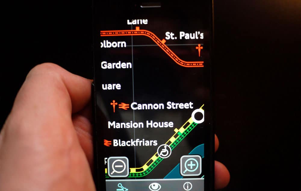
London underground map redesigned for easier viewing by people with all forms of colourblindness, and other vision impairments such as cataracts, loss of contrast sensitivity and myopia. If you have difficulty using the London tube map, either in print or in other apps, this could be the answer.
- Official licensed London tube map, modified with permission from TFL
- Designed for and tested with people with a range of vision impairments
- Combination of colour and pattern for colourblindness
- Increased contrast and reduced glare for other vision impairments
- Large detailed maps that allow a high level of zoom
- Simple easy to use interface with no fiddly gestures
- Choice of text size
This app (1, 2) has been designed for people with mild-moderate vision impairment, key features being alternative colour schemes, a high level of zoom, and a large font option. Considerations have also been made for people with impaired motor ability, with large well-spaced buttons, and use of zoom buttons instead of pinch/zoom. The interface is simple, settings have visual previews, copy is clearly styled and as jargon-free as possible, and the choice of interface colours can be beneficial for irlen-related dyslexia.
Source: Access Tourism NZ


